Dear 1-1 and 1-9,
I just checked the contact list and some of you still have not updated the contacts yet, PLEASE DO SO AS SOON AS POSSIBLE.
Please click below to get your pre-learning list, it will be available only for one week.
Pre learning list
Thanks.
Miss Zheng
Sunday, January 16, 2011
Thursday, January 13, 2011
Pompeii Exhibition to the Naitonal Museum
Dear 1-1 and 1-9.
I have five slots for each class to go to the Pompeii Exhibition in the National Museum on the 18th of Jan 2011 (next Tuesday) from 1.15pm to 3.45pm.
The exhibition is free and there is two way transport provided to and fro from the museum.
What is it about?
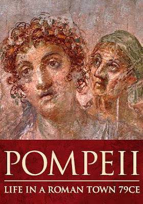
Photo credited to National Museum
It's about life in Rome in 79CE which was buried under volcanic ash and pumice due to the eruption of of Mount Vesuvius in southern Italy.
As spaces are limited. It will be given only to those who make a comment on the tag board.
Please indicate your name, class and index number for you interest in this exhibition. It will be good for those who can go as it would be a good starter for the chapter and study of Volcanoes next week. PLEASE INDICATE INTEREST BY TONIGHT!13/01/11, THE FIRST FIVE FROM EACH CLASS WOULD BE AWARDED THE PLACE TO GO. The exhibition is FREE!
Thanks!
Cheers!
Miss Zheng
Administration for 1-9
Dear 1-9,
Please remember to prepare the following:
Please remember to prepare the following:
- An exercise note book for note taking
- Decide on the colour of the geography file, the cheap plastic ones with holes are fine, not the slot in kind.
- Please fill up your contact information by clicking onto this link Class Contact 1-9 and fill the information.(PLEASE REMEMBER TO CLICK ON "FILE" at the left top corner and SAVE the document after you entered your details and exiting the link)All information is confidential and SHOULD BE ONLY FOR TEACHERS' USE.
- Please remember to birng both your textbook and workbook at ALL TIMES.
thanks!
Cheers!
Miss Zheng
Wednesday, January 12, 2011
Adminstrative Stuff for 1-1
Dear 1-1,
Please remember to do the following:
1) To download and print the pre-learning list and file it in your Geography File once you get it. (Do it once Sharepoint is ready to access)
3) Bring your textbook and workbook every lesson.
4) Please bring an exercise book (Geography Notebook) to do note-taking during Geography class.
5) Please fill up your contact information by this Friday (19/01/11) by clicking on this link:
1-1 Class Contact (PLEASE REMEMBER TO CLICK ON "FILE" at the left top corner and SAVE the document after you entered your details and exiting the link)
All information is confidential and SHOULD BE ONLY FOR TEACHERS' USE.
Cheers!
Miss Zheng
Tuesday, January 11, 2011
WELCOME 1-1 and 1-9!
Dear 1-1 and 1-9!
Welcome to Jiak Kopi!
This is one of the many platforms that I will use for teaching, mainly this blog is for me to put up videos that I may show in class for you to go through them and re-cap or to put up questions and answers that your classmates may ask or I may post for food for thought.
So check this site once a week at least!=)
Cheers!
Miss Zheng ;)
Tuesday, August 10, 2010
Questions for Sec 2 MR (CA3)
Hi guys from 2-5 & 2-9,
Below are some questions posted by your peers and might be useful for revision if you need it. The newer questions at the top and the older ones at the bottom. Cheers! Hope mugging for Geo, Sci and Maths have been well over the weekend.
I don't understand chap 3 revision paper, qn4. (Ben 2-9)
For this questions, first you need to know what is the sequence of of the different settlements. the first type of settlement that is very common and can be found mostly everywhere is your villages.That is why they form the base of the pyramid, because in terms of absolute number of village settlements, there are many, but the size of the village settlement is small.
Next, when many small village settlements group together, they form a town, so that is why they form the middle part of the pyramid. There are not as much towns found as compared to villages BUT the size of a town as a settlement, is larger than that of a village settlement.
Lastly, many towns form your city, and that is why it is at the top of the pyramid. The number of cities is lesser than that of a town or village found in the world, but the size of a city is very much larger than that of a town and village.
For instance, Blk 451, Blk 452 of bishan street 22 forms your villages, together, they form Bishan Town, then, AMK town, Bishan Town, Pasir Ris Town, Telok Blangah Town etc, all the towns in Singapore form your Singapore City. There are many many blocks (villages) in Singapore, fewer number of Towns, and there is only one City (Singapore).
Hope this illustration helps.
Chapt 4 revision paper, qn 10,why the answer is D and not C? (Wei Yang 2-9)
A Water that floods the fields has been treated.
B More fertilisers have been added to the slopes as there is much soil erosion.
C The slopes have been flattened to allow crops to be grown.
D Steps have been cut into the slopes to create flat land.
Wei Yang, the picture shows a land which is not flat, probably a hill. It shows terraces, which mean, the original, sloped land has been cut into the step like terraces you see in the picture, thus answer has to be D and not C.The slopes are not flattened, if it is flattened, then you would not see steps at all.
Miss zheng, what do u call a pyramid that has bulging top, normal middle, and a thin bottom? (Yikai 2-5)
2-5 Wayne: inverted pyramid? (Yes it can be called an inverted-like pyramid)
But it really depends on what it looks like, so depends on what the diagram shows. If you really cannot decipher the shape, then I advise for you to describe the shape.
In chp 4 revision paper ques 9, why is 'B' the answer and not 'C'? And for ques 11, why is the answer 'A' and not 'C'? (Kang Qiao 2-5)
For Qn 9, answer is B, as inputs for wet rice is not as much as compared to C. First you eliminate the answers A & D as output per land area is low in this two but wet rice output per land area is high. So answer can only be B or C. But for C, it’s a better answer for high tech farming where inputs are very high (esp capital) & land area very small. B is a better answer as inputs are not as much as high tech farming and the land area is not as small as high tech farming, so B is a better answer to choose for Wet rice cultivation and I would say ans B is for High tech farming.
What’s the difference between factors and reasons.(Yuren 2-5)
Depends on the questions, they are quite similar. but factors in population u gt to think about BR, DR, Immigration rate, Emigration rate etc. reasons, tend to be longer answers and are elaborated.
What are some of the components of the human environment? I. %9The people occupying an area II. %9The movement of people or goods from one place to another using vehicles %9III. %9The growing of cr err in the 1st revision paper 2nd quetion, why is the answer C? shouldnt burning fossil fuels be also human activity? (Yi Kai 2-5)
COMPONENTS of Human environment. Still remember PSATC?Population, Settlement, Agriculture, Transport & Communication. So ans is C.
I. The people occupying an area (Settlement)
II. The movement of people or goods from one place to another using vehicles (Transport)
III. The growing of crops (Agriculture)
IV. The burning of fossil fuels (Human ACTIVITY not COMPONENT)
What is grid settlement? (Kang Qiao 2-5)
Grid settlement is more like how a town is being planned, like a grid. You need not know that , you just need to know only what is a dispersed, linear and nucleated settlement.
How are wet rice cultivated on hill sloped irrigated? (Kang Qiao 2-5)
Hills are cut into terraces, mud walls called bunds are built & then they are flooded in order to grow WET rice. They are irrigated like on normal flat land through irrigation canals built alongside the slope. natural rainfall can also flood the terraces.
May i ask why is it that for shifting cultivation, only small land is needed? And for plantation agriculture, are the felled trees burned?(Kang Qiao 2-5)
Small land is needed as shifting cultivation is for subsistence, but large forest land is cleared as it would be easier to clear a large land area first so that the family need not have to do the labourious work of having to clear again the next time they shift to a new area to grow crops. For plantation agriculture, yes, felled trees are burnt also for the reason as a source of fertilizer or nutrient. It also makes the work easier for plantation when burning is carried out as weeds, or competing plants will be rid off already.
Hey miss zheng, may i know how to explain for fluctuating trend? Like do u write increasing in a fluctuating trend? or decreasing? since fluctuating is up and down both? (Yikai 2-5)
Flunctuating trend, the characteristic is that it goes up and down. If the values overall goes up, you say fluctuating increasingly, though it is going up n dwn.unless its constant across, its just fluctuating up and down (no increasing or decreasing)
Tuesday, May 4, 2010
Questions asked for MR 2
How to describe the process of exfoliation in a shorter way?
There is no shorter way, look at Page 92 to know how to explain. The key concept is the repeated expansion and contraction and about these two forces being against each other resulting in uneven expansion or contraction which weaken the rock’s SURFACE LAYER. And as said in class, with water present, the surface layer will tend to crack more easily and break off in layers.
Did you not listen in class for the worksheet I went through? And you cannot find the answer yourself?
Look at Page 146 of your textbook.
In general, polar climate experiences VERY low rainfall throughout the year and very low temperatures (below FREEZING POINT) for majority of the year.
Why are the most of the active volcanoes located at the pacific ring of fire?
Most active volcanoes are located at the pacific ring of fire as this is where the impact of movements is the greatest in the boundaries of the plates that are found around the pacific ring of fire as compared to other places.
Who might use satellite images?
Look at page 67 of textbook. Usually people who study changes in the environment, for instance, specifically the meteorologists who can use satellite images to forecast weather or warn people about dangers such as hurricanes. Environmental scientists who warn people about the impact of global warming through the study of the satellite images of ice cap melt in the north pole.
What is the meaning of fieldwork?
Look at page 8 of your textbook.
Fieldwork is work at first hand, which means gathering evidence directly from the environment rather than from books or other references/resources. For instance for your eco tourism project, you did fieldwork to gather information about the tropical rainforest by observing the tropical rainforests instead of reading off the information easily from the Internet.
What is the definition of transpiration?
Transpiration is the process where plants give out water vapour into the air through their leaves.
How to write numerical data?
What kind of numerical data you are talking about?
Look below for hints.
How to read tables:
1) Study the columns in the table carefully-the headings, the items, the units of measurements.
2) Look for extreme values in figures, example: the highest and lowest, largest and smallest, densest and least dense.
3) Look for any links or patterns/trends between the values and between the items and the values in the columns. Make general statements of what is observed.
4) Some questions would require you to read values directly form the table, others may require you to do simple calculations based on the values given in the table and others might require you to infer (decipher/interpret) from the given values.
Steps in reading line graph
1) Study the graph carefully and take note of the headings, the x-axis, the y axis and the units of measurements.
2) Note the values, example the highest and lowest values.
3) Observe the gradient of the line which indicates the rate of increase or decrease.
4) Note the relationship between the x-axix or y-axis.
5) Some questions might require you to read directly from the graph while others may require you to calculate or even infer from the given values.
Reading a bar graph
1) Study the information on the x-axis and the y-axis carefully.
2) Look at the distribution of the data , for example, the point with the highest or lowest value.
3) Take note of any changes that may have taken place in the data, example, the increase or decrease in that value.
4) Loof for any links you may find between the x-axis and the y-axis.
Reading Pie charts
1) Look at the pie chart or the legend on the pie chart to find the value of each item.
2) Locate the largest amount, followed by the next until the last amount which is the smallest.
3) Read the questions carefully and answer them, using the numbers (numerical data) correctly.
4) Some questions might require references to be made from the values givem.
Reading combination of data representations (e.g climograph-bar and line graph)
1) Study the information in each represntaiton closely using the skills you have acquired.
2) Look for relationships shown in each representation (e.g for climograph, mean annual rainfall or temperature, temperature range (highest temperature of the month and lowest temperature of the month)
3) Look for links between the representations ( High annual rainfall and temperature)
4) Analyze the links between the representations using prior knowledge you have about the links. (means most probably climograph is representing a tropical climate.)
Which is the hardest rock and why?
The hardest rock among the three types of rocks is the igneous rock. Igneous rock when they formed are formed where the crystals of the minerals grow closely together with no lines of weaknesses or air pockets that allow weathering agents to attack.
Whereas sedimentary rocks are usually layered (lines of weaknesses), moreover some sedimentary rocks are compacted together with different sediments of different sizes, there might be air pockets in between the rocks when they are in the process of cementing each other.
For metamorphic rock, some rocks are made up of sedimentary rocks (which already have lines of weaknesses), if they are made up of igneous rock, even though there is highly no lines of weaknesses as compared to sedimentary rock, but as the igneous rock undergo intense heat and pressure, it becomes weaker [think in terms of heat can melt the rock and pressure can cause the rock to form folds leading to cracks etc]. That is why among all three, igneous is usually the hardest.
Pushing causes fomation of mountians, then what does pushing ands sliding form?
You mean, what does pulling and sliding form?
Pushing can form mountains and volcanoes
Pulling can form new ocean floor, ocean ridges (e.g Mid Atlandtic Ridge)
Sliding tend to form faults (e.g San Andreas fault )
All of these, pull, push and slide can cause your earthquakes and all tend to happen at plate boundaries.
What is the difference between aerial and satellite photos?
Aerial photographs are taken above ground from an airplane or a tall building whereas satellite images are usually taken by instruments on board a satellite.
Aerial photographs show a bigger area than a landscape photograph, usually at a local or national scale, on the other hand, satellite images show a large area on the Earth's surface, usually at a regional or global scale.
Aerial photographs are usually used to help to estimate the size of a feature or an area, such as the area of a school whereas satellite photographs are usually helpful in studying the changes in the environment.
Answers all found in Pg 66-67 of textbook.
How is human environment formed?
A human environment is formed when a physical environment is changed as a result of human activities. For example, humans make changes to the living environment to suit one’s needs, using materials (natural resources, pg 21 in textbook) which humans can find in the physical environment for their own use (specific example: clearing forests and using the wood to build houses.)
The physical appearance of igneous rock is that it has a crystalline appearance, where some are coarse-grained or fine-grained whereas, for sedimentary rock, it is usually layered in appearance.
Time zone is the zone/area in which a place/location experience a specific standard time. Each time zone represents 15 ° longitude or the distance the Earth rotates in one hour.
No. Greenwich Mean Time is the base time zone at 0° longitude (Pg 40 of textbook), whereas International Data Line is the 180° longitude that lies directly opposite the Greenwich Meridian 0° longitude. And GMT is not equal to Greenwich Meridian. GMT is the time zone found at the Greenwich Meridian (0° longitude)
How does the human environment affect the physical environment positively?It is not the human environment per say that affect the physical environment, but more of humans changing the environment for their own use, be it having positive or negative effects.
Humans can affect physical environment positively for instance be re-forestation (replanting the forest) or re-growing the place that was once destroyed either naturally(through natural disasters) or through human activities.
Is there any distinct weaknesses of using between Satellite and landscape photos?
The main weakness of satellite photos are that they do not show physical or human features in great detail as compared to landscape photographs.
The main weakness for landscape photos is that a landscape photograph which are taken at ground level and covers only a SMA LL area whereas satellite photos takes photographs of a LARGE area on the Earth’s surface.
How to draw the cross profile of a mountain or hill?
See page 54 and 55 of text book, the height of the contour will coincide with the Y-axis of the graph below. And label the distinct features such as rounded summit, steep slope and a height of more than 600m for a mountain and the features seen for a hill if you draw a hill.
What is landscape photo limitaion?
See answer above
You can add on that as it covers a small area, it cannot help study changes in the environment on a global or regional scale.
Another limitation would be as compared to satellite images, landscape photographs are usually not taken in “real time” where images can be viewed within seconds after they have been taken.
Is plain a landform?
Yes, plain is a type of physical landform.
How are stalagmites and salactites formed?
You need not know the detailed process but you need to know that it is due to weathering and formed from action ofwater where acidic rainwater can dissolve limestone to form them and are usually found inside limestone caves. Action of water also formed landforms such as caves. For instance in Jenolan Caves in Australia, or what I have gone through in class, Har Long Bay in Vietnam or Guilin in China. All of which are limestone caves.
You need to know that stalagmite is the landform structure that is from the ground, whereas stalactites are landform structures from the ceiling.
Subscribe to:
Posts (Atom)